Hamlets
THE HAMLETS OF URSWICK PARISH
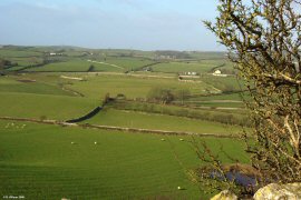
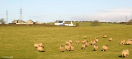
The view looking west from Skelmore Head Fort, situated to the north east of Great Urswick, shows Hallier How in the middle distance and the white properties at Mascalles in the left distance.
Clearly evident are the rolling contours of this inland portion of the parish, formed by glacial till draped over the faulted limestone bedrock beneath.
The increasingly popular use of white masonry paint can steal the eyes’ attention from the parish landscape and persist in drawing it back, in this instance, to the former old farmhouse of Beckside Farm.
This modern-day small hamlet, located alongside Gleaston Beck, which drains Urswick Tarn to Morecambe Bay, results from the conversion of the old farm’s former outbuildings to three dwellings. The more distant and more isolated farmstead of Harbarrow may be seen on the far horizon, sitting on the highest drumlin in the parish. The drumlins become increasingly massive towards the parish’s southern border and continue to grow in size across neighbouring Aldingham Parish.
Whilst each drumlin itself amounts to a huge amount of material carried south from the Coniston Fells by glacial ice, the collective of drumlins on the Furness peninsular is earth movement on a truly gigantic scale.
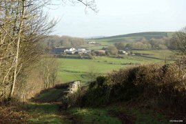
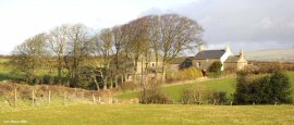
This elevated position in Dimples Hole Lane affords views to the neighbouring high ground where Causey Wood Farm may be seen in front of the more distant Woodside Farm, itself nestling beneath the flat plateau of Skelmore Head Fort.
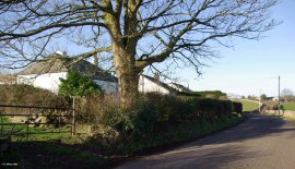
There are several similar lanes throughout the parish providing access to farmland remote from the country roads.
In modern times they are particularly popular with walkers and not uncommonly provide connections with other strands of the extensive network of footpaths across the district.
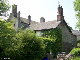
Hawkfield, now a small quiet hamlet, was formerly, and for many generations, the farmstead seat of the Cranke family.
James Cranke the elder (1707-1780) and his son, James Cranke the younger (1746-1826), became nationally known portrait artists, and it is worthy that examples of both their work forms part of the religious decoration of Urswick Parish church.
The hamlet now consists of the converted original large dwelling, its converted outbuildings, plus two bungalows constructed in the 1950s for employees at nearby Bolton Manor Farm.
Highfield, together with its near neighbour, Skells Lodge Farm, are close to the western border of Urswick Parish. Their location on the rolling fertile grasslands belies the massive amount of limestone beneath, but the great depth of Crown Quarry, in close proximity to their south, is inescapable evidence of the once tropical location of this now pastoral place.
Mascalles occupies high ground looking towards Lindal in Furness and the Furness Fells.
Originating from the time when the nearby extensive haematite mining facilities were being dismantled and their materials sold on for second use, this hamlet now enjoys views over fields and distant hills which would have looked unrecognisably different when the Furness peninsular was one of the richest sources of iron ore then known.
Skells Lodge is a farmstead which has remained unspoilt from its original form to the present day, and still operates as a small country farm.
Fronted by a splendid line of mature trees and located on a quiet country road, this is a rare treasure indicative of what was once so common around these parts.
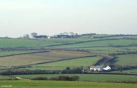
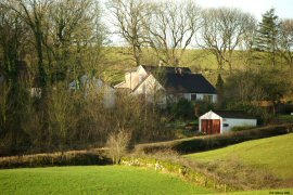
The white properties in the middle distance are the tiny hamlet of Skeldon Moor which is made up of a total of five dwellings scattered along a quarter mile of country road.
Across the fields beyond may be seen Hawkfield, behind which, on the skyline, is Devonshire Quarry located at Stainton with Adgarley.
Despite its small size, Skeldon Moor once had a pub, now a private house, which was named ‘officially’ as The Traveller’s Rest but, for some reason, was always known to locals as ‘The Wax’. The pub was owned by the local brewers, Cases Ales.
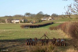
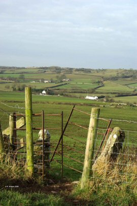
This photograph again illustrates the rolling topography of Urswick Parish with its strands of north-south aligned drumlins and its enclosed fields of rich pasture.
Well Cottage, dating from 1642, and a small number of other old properties make up the small hamlet of Well House located at the end of an extremely quiet cul-de-sac, accessible by a small country road from Bardsea village, or via a footpath from Birkrigg Common.
With the high common ground to the west, the sea of Morecambe Bay to the east and woodland to the north and south, Well House is truly gifted.
Enclosed on three sides by mature trees and sitting in an elevated position adjacent to Hooks Lane; Woodhead, which consists of five dwellings, is easily missed and not known to many.
It is neighbour to Dimples Hole Lane, alongside which new agricultural developments have commenced in the form of a stock housing shed and apparently supporting resources.